OysterCatcher Spring 2022
Students Explore Growing Oysters Through Aquaculture
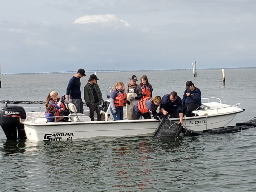
Students with the Conservation Corps of the Forgotten Coast deploying aquaculture cages on lease.
By Anita Grove, CTP Coordinator
Students with the Conservation Corps of the Forgotten Coast will learn about oyster aquaculture first-hand this year through an exciting collaboration between the Reserve, Conservation Corps of the Forgotten Coast-OysterCorps, Rattlesnake Cover Oyster Company, the Florida Department of Agriculture and Consumer Services (FDACS) Division of Aquaculture, and the FSU Coastal and Marine Laboratory. Students have an aquaculture lease in Apalachicola Bay where they will plant, tend, and harvest oysters while documenting the project and sharing their experiences with the community throughout the year.
The program is made possible by a grant from the NOAA and the North American Association for Environmental Education (NAAEE). The eeBLUE Aquaculture Literacy grant will enable students in the OysterCorps to experience the opportunities, challenges and benefits of oyster aquaculture through direct engagement with local experts.
In late October Todd Bracken and Jeff Wren, owners of Rattlesnake Cove Oyster Company, showed the students how to build aquaculture cages and over the course of a few sessions they built 60 cages, 25 14mm cages and 35 18mm cages. The cages are constructed out off a strong plastic mesh folded into a rectangle and outfitted with floats.
December 8, 17 students visited their lease for the first time aboard the Reserve’s research vessel the Tideline. Guided by Todd and Jeff the students divided up 21,000 juvenile oysters into the 10 of the cages. These cages were secured and then deployed by the students on their lease as staff from FDACS and Reserve staff looked on. Average size of the juvenile oysters was 6-8mm.
January 27th, students traveled out to the lease to tend the oysters and split them into new cages to reduce density so that the oyster can grow. They transferred the oysters from 9mm bags to 14mm square mesh bags. The average size of the oysters had increased to 1.5 inches, with several observed at 2 inches! While tending the lease students observed a diversity of other marine organisms present on the lease-stone crabs, blue crabs, mud crabs, blennies and grass shrimp, were living in or around the of the cages.
Students will tend the lease over the upcoming year. They will document their progress and share what they learn with the community through presentations at community events and via social media. Franklin County High School students are planning a visit to the lease where OysterCorps students will share lessons learned with their peers.
The aquaculture program started in the fall of 2021 and will continue until the fall of 2022. It was made possible by a grant from the NOAA and the North American Association for Environmental Education (NAAEE). The eeBLUE aquaculture literacy grant will enable students in the Conservation Corps to experience the opportunities, benefits, and challenges of oyster aquaculture through direct engagement with local experts, as well as NOAA and NAAEE resources. Stay tuned for regular progress reports! To keep up with the OysterCorps progress, check out the Friends of the Reserve Facebook Page https://www.facebook.com/ApalachicolaNERR/ and the Corps Facebook page Facebook.com/conservationcorpsforgottenemeraldcoasts/.
OysterCorps is a training academy based within Conservation Corps of the Forgotten and Emerald Coasts (CCFEC). The program seeks to restore oyster habitats, strengthen coastal resilience in the face of climate change, and drive economic diversification through aquaculture. OysterCorps participants are opportunity youth ages 17 through 25 (and veterans up to age 29) who reside in the Florida Panhandle. The program is supported by The Corps Network’s AmeriCorps Opportunity Youth Service Initiative (OYSI). Participants who complete the program earn a series of certifications, over 700 hours of hands-on field experience, and an AmeriCorps education award.
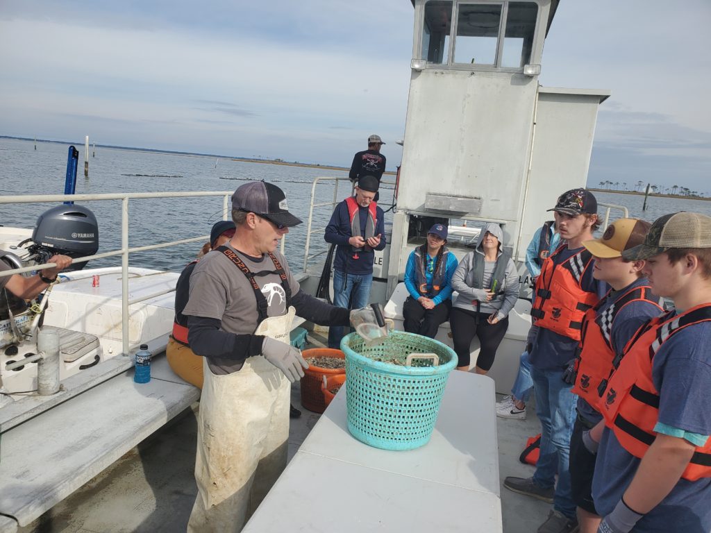
Todd Bracken showing students how to load cages with juvenile oysters.
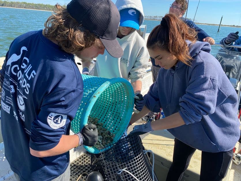
Transferring oysters to larger cages.
Explore, Preserve, Enjoy Our Special Place
By Jenna Harper, Reserve Manager
As I write this, little hints of Spring are starting to show everywhere. It is an exceptional time of the year along the Gulf coast as plants push up out of the ground, all sorts of creatures are more active, and some mornings there is still a crisp bite to the air. It is the perfect time of the year to get out and explore our vast forested floodplain, our coastal uplands and our barrier island beaches (see our program highlights). While we are encouraging everyone to enjoy this special place, we also want to people to recognize and appreciate the unique opportunity it is to have access to so much conservation land. It is incumbent upon all of us to be stewards of the natural resources that surround us not only to conserve those resources but to ensure that future generations have the opportunity to share the experience. The Reserve published the first Roadmap to Recreation in 2016 to showcase low-impact recreational opportunities available within conserved lands across our region, including activities such as primitive camping, hiking, paddling, and bird watching. The brochure also highlighted statewide recreation programs including the Great Florida Birding and Wildlife Trail and the Florida Circumnavigational Saltwater Paddling Trail. A digital version of the Roadmap can be found on our Friends of the Reserve website at ApalachicolaReserve.com. We are currently in the process of updating the Roadmap, and we are anticipating an updated version will be available by summer 2022.
After a two-year hiatus, we are going to be celebrating Estuaries Day on May 6. We are very excited to Welcome Back everyone to the Reserve and to our biggest education event of the year. There will be some of the most popular activities and games from previous years, but there will also be some new exhibits and activities.
Included this year is the Below the Waterline exhibit which highlights the condition of oyster reefs in Apalachicola Bay. We will have the Apalachicola Bay System Initiative team on site to answer questions about the status of oyster restoration in the bay. We will also have exhibits and activities highlighting the use of living shorelines as a habitat conservation and restoration tool with representatives from the Franklin-98 project and the Conservation Corps of the Forgotten Coast. Come visit us on May 6 to learn more about your local estuary, the status of current research and restoration, and new opportunities to explore at the Reserve.
The Reserve and AU Study Environmental Impacts
By Jason Garwood, Research Coordinator
ANERR Research staff seem to have their hands into a little bit of everything when it comes to studying the wetland habitats surrounding the Apalachicola Reserve, and in the past year that hand has grown a bit bigger. More recently, research staff have been collaborating with Dr. Christopher Anderson, Associate Professor at Auburn University to conduct a study to evaluate potential changes in tidal freshwater forested wetland communities along the lower Apalachicola River.
This particular study will correspond to a project Dr. Anderson conducted more than 10 years ago to look at these communities along a salinity gradient through the lower river forested flood plain. This continuation of the original project was initiated in spring 2021 with the installation of the research infrastructure, which consisted of three Aquatroll 500 water quality and depth sensors in the subtidal freshwater creeks in the St Marks, East River, and Saul’s Creek distributaries.
Staff have also installed sediment pore water wells, three at each site, to monitor changes in water quality within the sediments surrounding these marsh plant habitats. Staff are maintaining the sites and are visiting each location on a monthly basis to download data and collect measurements from each of the wells. These data will be related to Apalachicola Bay tidal stage and river discharge data. As a result, the water quality data, when coupled with the vegetation data will provide insight on how these communities are changing in response to changes in water quality, which is expected to be directly related to both the flow coming down the Apalachicola River, and the force of the tide coming in from the Gulf of Mexico.
During the summer and fall sampling season of 2021 and continuing into summer 2022, the original forested community study sites along the lower distributaries have been reestablished and monitoring has since begun. These data will be used to compare current conditions to those conditions previously examined between 2006 and 2010. To accomplish this task, sites consisting of a 500 m2 forested plot are being used to collect data on the plant communities. Within each circular plot, forest trees are identified and measured in diameter at breast height. Shrub identification, count surveys, and species-specific understory vegetation cover data are also collected within each plot.
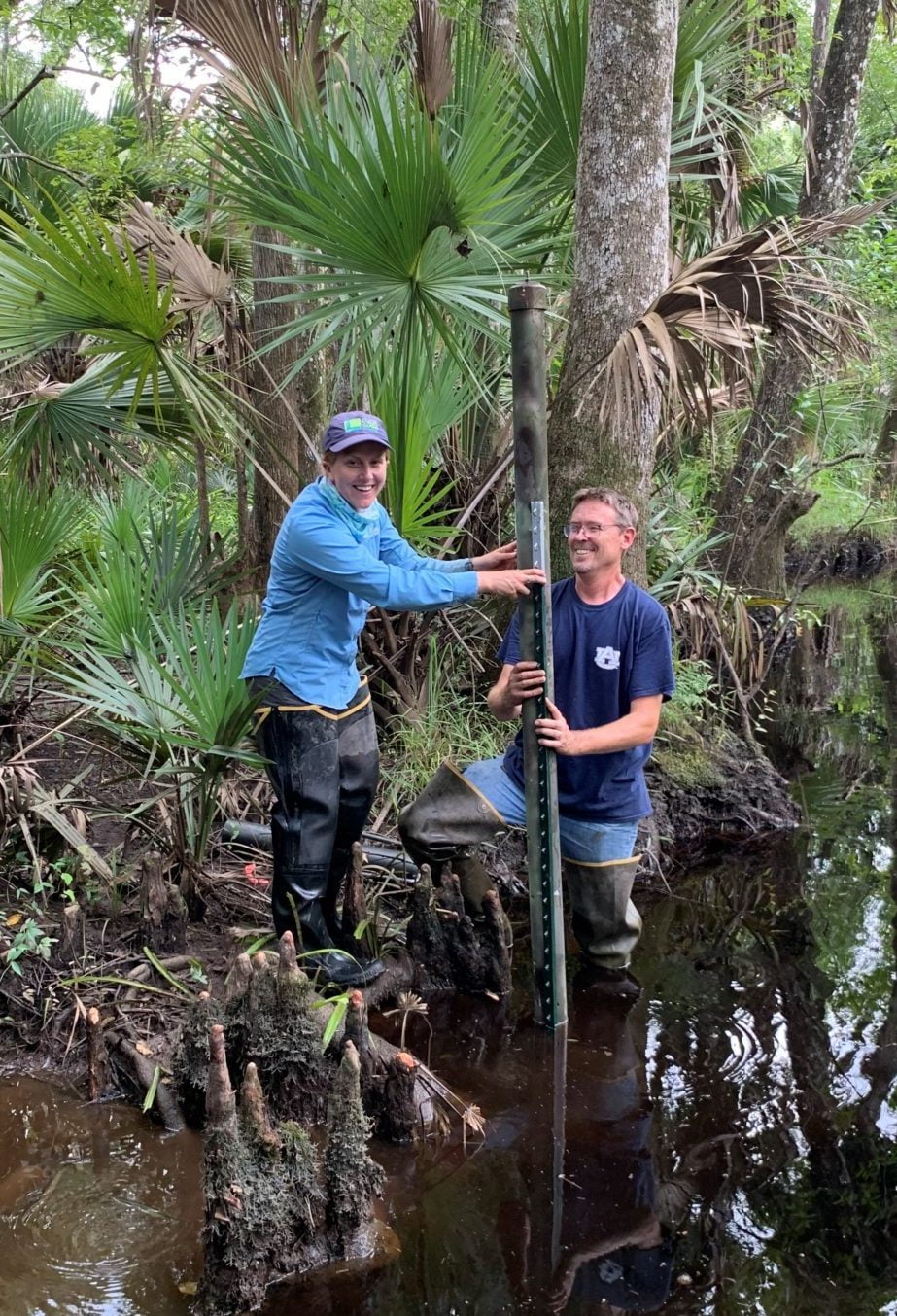
Research staff, Sam Lucas (left) and Dr. Chris Anderson (Right) install a PVC tube, which houses one of our three Aquatroll 500 water quality loggers in one of the subtidal distributaries.
The data collected from this project will provide great insight into the current efforts the ANERR Research staff are already collecting on the effects of climate change, sea level rise, and reductions in freshwater discharge are having on plant and animal communities along the lower Apalachicola River and Bay. Our current plan is to continue our efforts to track and document these changes to show the impacts these often human-induced environmental changes have on our local wetlands.

Dr. Anderson measures and (Far Right) tags trees at one of our monitoring sites.
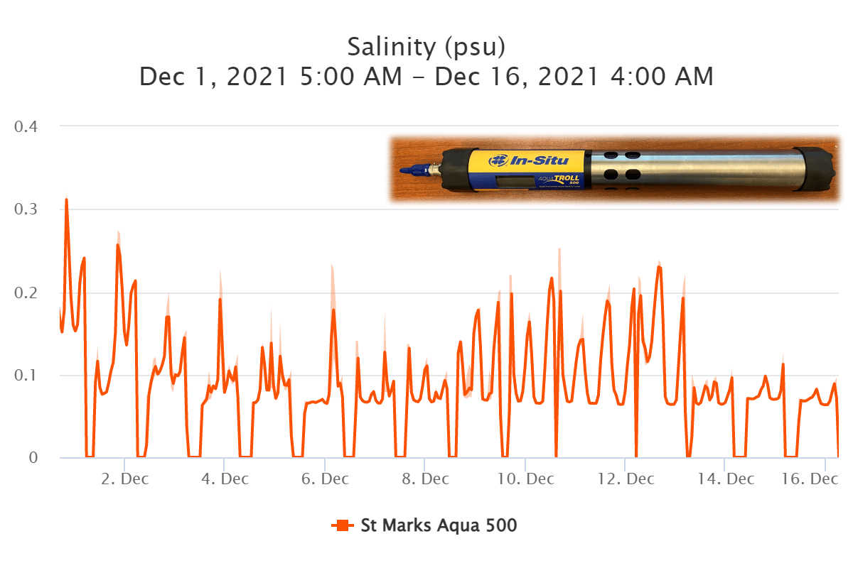
Data showing fluctuations in water salinity, which correspond to tidal fluctuations at our St. Marks distributary location.
The Outdoors to Benefit All
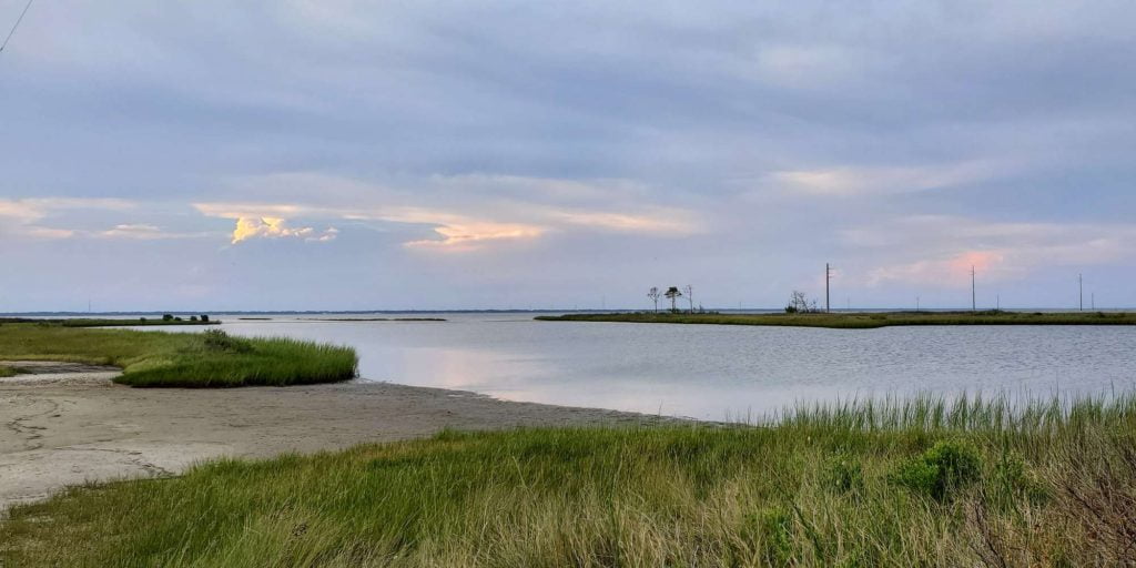
Nicks Hole on St. George Island provides public access and a Chronolog citizen-science monitoring station. This is one of several ANERR managed, low-impact and ecologically sustainable recreation opportunities,
By Cait Snyder, Stewardship Coordinator and Lexy Preheim, Stewardship Specialist
Recently, we’ve spent more time disconnected than we may like to admit. Much of our lives have been reduced to familiar faces and screen time, whether working remotely, post-poning celebrations, or social distancing at home if our loved ones were sick. Rest the eyes, stretch, reconnect, repeat. Thus, opportunities to escape to the outdoors are more important now than ever. Nationwide, land managers have labored to maintain public access to outdoor resources, recognizing the need for respite and natural recharge throughout the pandemic. The Stewardship crew at ANERR has been one of those teams working to keep our opportunities safe, accessible, and enjoyable. Luckily, it’s easy to find many opportunities in the Apalachicola area.
One of our top priorities at the Reserve is to provide low-impact and ecologically sustainable recreation opportunities, emphasizing the quality of experience over quantity. Across the 6,800 acres of Reserve managed
lands, staff regularly maintain more than nine miles of primitive hiking trail, three miles of multiuse road, two kayak launches, and nine primitive campsites stationed along Florida’s saltwater paddling trail. Experiences can be enjoyed at public properties managed by the Reserve across St. George Island, Eastpoint, Apalachicola, Little St. George Island, and, of course, on the water.
The Reserve made improvements at several recreation areas over the last year. One ongoing project involves refurbing the old Scipio Creek Boardwalk near Mill Pond in Apalachicola. Designated recently as “Woody’s Walk” (after a former manager), staff and volunteers restored 0.5 miles of existing elevated boardwalk and an observation platform with the help of the Conservation Corps of the Forgotten Coast. Another elevated boardwalk, repaired after Hurricane Michael, remains popular with tourists and locals at the Nature Center in Eastpoint, and ends with a grand view of St. George Sound. In additional, for a more primitive walk, Cat Point Trail meanders for half mile through palmetto flatwoods in the property across Island Drive. Our coastal properties, however, can flood occasionally due to storms, tides, and low elevations. To adapt, two new and simple footbridges were constructed to keep feet more dry and reduce impacts to the surrounding marsh and substrate.
Other site improvements included conversion of a derelict bath house to a picnic-storm shelter, installation of guest trail registries, replacement of gates and interpretive signage, and restoration of native trees.
Visitors can get involved in monitoring reserve lands through Chronolog photo-monitoring, an easy-to-use worldwide citizen-science tool used to create time lapses from photos submitted by the community. At the St. George Island Bridge location, visitors can help us monitor a growing mangrove population, recreation use at a primitive launch, and the changing shoreline. A second station is within the Nicks Hole property, accessible by water and private road, and located towards the western portion of St. George Island. This station will track changes from fire and storms, potential sea level rise, and compliment other monitoring stations such as Surface Elevation Tables (SETs). A digital time lapse for both can be found at Chronolog.io/.
Within the Apalachicola Bay region, several recent land acquisitions have the potential to generate many new recreational opportunities. In early 2020, over 20,000 acres of land surrounding Lake Wimico, a large freshwater lake west of the Reserve, was placed into conservation (Box R WMA and Apalachicola River WEA). This tract contains critical freshwater wetlands important for fish and migratory wildlife and for the water quality of the Apalachicola River and Bay. Lake Wimico is also popular for bass and fly fishing, sailing, and birding because of its remoteness; it’s a true hidden gem. Another valuable acquisition was secured in the fall of 2020 - the Bluffs at St. Teresa tract. It will be divided, restored and managed between the Florida Forest Service and DEP’s Division of Parks and Recreation. Located between Bald Point State Park and Tate’s Hell State Forest, the Bluffs offer a diverse ecosystem that provides a home to local wildlife and also recreation such as hiking, wildlife observation, and (eventually) camping.
Between new and existing public properties, local and state staff are working on ways to restore and conserve our unique and diverse natural resources. Now is the perfect time take a break, heal, and get outside to explore the Reserve and its surrounding natural wonders that we are so lucky to have.
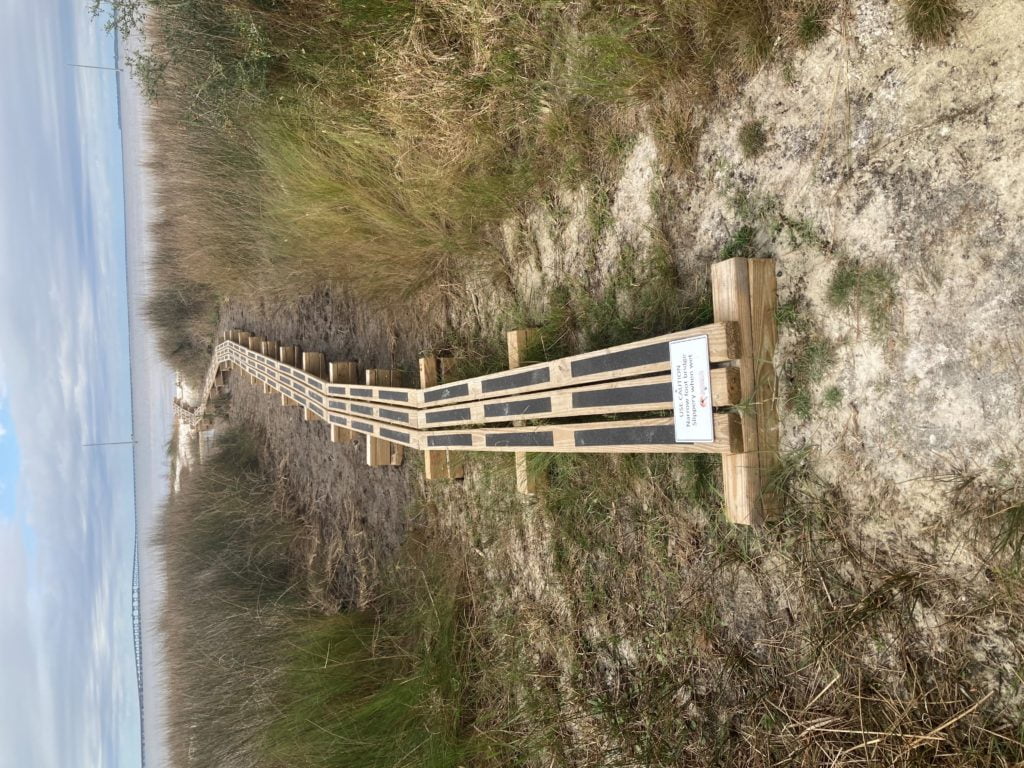
Top: A footbridge to keep feet more dry and reduce impacts to the surrounding marsh and substrate.
Bottom: The Reserve regularly maintains over nine miles of primitive hiking trails within its 6,800 acres. Visit ApalachicolaReserve.com for information on outdoor recreation opportunities available in the Bay area.
Know with Beachcomber ID
By Jeff Dutrow, Education Coordinator
ANERR’s Education Department announces our latest project, Beachcombers ID Hotline! Participants submit to the Hotline photo(s) of something found while combing our bay or Gulf beaches. We identify the object or animal and provide a description of characteristics and niche within the ecosystem. Included are fun facts on unique adaptations or anything extra interesting. Visitors and residents alike are encouraged to utilize this educational resource for fascinating, strange, or just-your-average beachcombing finds.
The Beachcombers ID Hotline has received doz ens of submissions in its first few months ranging from animals and animal traces, to sea beans and empty shells, to the macroalgae we know as seaweed. Some of our favorite IDs have been a polka dot batfish (Ogcocephalus cubifrons), a yellowline arrow crab (Stenorhynchus seticornis), graceful redweed (Gracilaria tikvahiae), and brown hamburger beans (Mucuna sloanei driftseeds). We are excited to see what other finds may come our way in the future.
We encourage everyone to check out the Beachcombers ID Album on ApalachicolaReserve.com. We post, with submitters’ permission, their local finds and our responses.
Through the Beachcombers ID Hotline and the Beachcombers ID Album, we hope to bring awareness to the array of species that live within and depend on the health of our estuarine and marine environments. Text us today! Beachcombers ID Hotline: (850) 895-1519
Please Note: Beachcombers ID Hotline is for a educational purposes only. To report an animal stranding or injury, please call the FWC Wildlife Alert Hotline at (888) 404-3922.
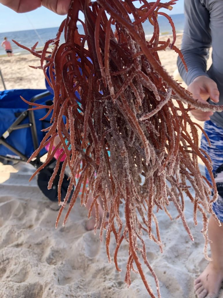
This is freshly-beached Gracilaria tikvahiae, commonly known as graceful redweed. Graceful redweed is a type of red seaweed, which in itself is multicellular algae very similar to plants but lacking any stems, leaves, or roots. Graceful redweed has bright red forked branches that can span up to a foot long and resembles a tangled clump of red spaghetti. After washing up it quickly bleaches clear, so the one you found here must have been a very fresh specimen.
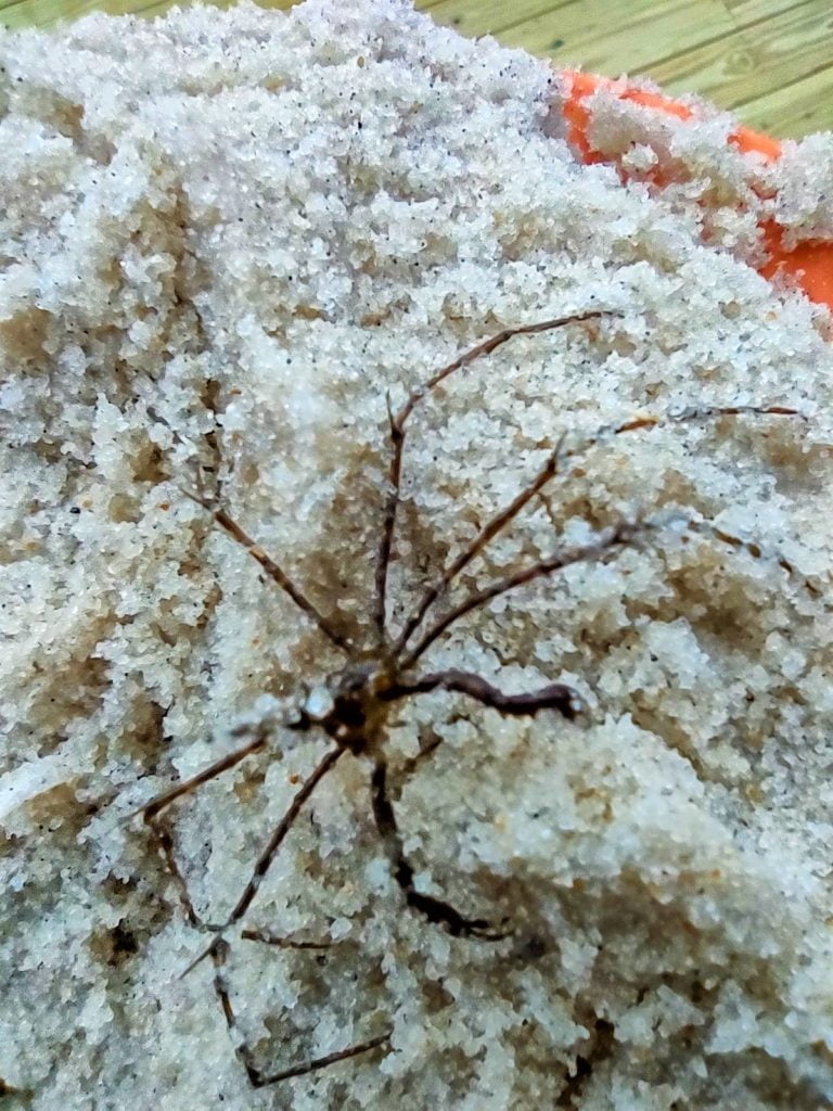
This is Stenorhynchus seticornis, a yellowline arrow crab, named for the pointed protrusion coming from its head. A nocturnal crab normally found in underwater crevices and coral reefs at depths of 10 to 30 feet, so it is quite unusual you found one on the water’s surface and during the day! It was likely displaced by the heavy storms we’ve been seeing here and out in the Gulf. Arrow crabs are the “cleaners” of their environment, consuming algae, bristle worms, and organic particulates that would otherwise impact growth of the coral reefs they live in. Interesting fact: Arrow crabs are docile around humans and readily allow handling by divers and aquarium keepers. However, they are extremely aggressive towards other crabs (even other arrow crabs) and will not hesitate to injure or kill a crab found within their territory.
